Viz|World creates 3-D maps with Microsoft Virtual Earth
News
By
TVTechnology
published
Add us as a preferred source on Google

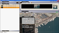
Vizrt has introduced the latest version of its Viz|World mapping software, Viz|World v1.2. The template-based system enables users to create branded maps and geographical animations in real time from within most of Vizrt’s control applications.
The new version of Viz|World is now fully integrated with Microsoft’s Virtual Earth platform for on-demand delivery of high-resolution satellite and aerial imagery. Real-time 3-D graphical elements can be added to the satellite imagery using the system.
For more information, visit www.vizrt.com.
Get the TV Tech Newsletter
The professional video industry's #1 source for news, trends and product and tech information. Sign up below.
CATEGORIES
