Local weather networks
One of the best ways to connect with the viewer is to provide accurate local weather forecasts and conditions. While it sounds simple, it’s actually quite complex. Local weather information can only come from local weather sensors. To get accurate information from a variety of locations, stations need remote sensors throughout the communities they serve.
One solution to gathering weather data throughout a station’s service area is to rely on the resources of the weather services located at airports. While there’s nothing inherently wrong with this approach, there may not be airports at all the locations for which a station would like to report weather information.
Distributed measurements
To accurately and effectively provide hyper-local weather data, more than 100 broadcast meteorologists use a new approach to build their own local forecasts by monitoring weather at the micro-climate level. At the same time, they can tap into a shared nationwide network of more than 6000 weather stations. In the United States, this network is owned and operated by WeatherBug Media Services in partnership with local TV stations.
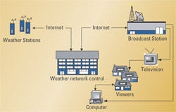
Figure 1. A network of 6000 local sensors allow the weather presenter to assemble data for any group of sensors over a defined area. This information can be combined with prepackaged data assembled by meteorologists at the network. Click here to see an enlarged diagram.
There are three key components to this all-digital network. They include the individual weather stations, a network center to collect and parse the data, and the local TV station’s presentation. (See Figure 1)
Approximately 6000 weather stations are located throughout the United States. They provide pinpoint-accurate data on weather conditions at each location. A centralized network control center gathers and parses the data from these weather stations for use by the local TV station meteorologists. This data can be used as a resource for forecasting or for on-air presentations and streaming real-time data.
The weather station
Each weather station houses a variety of meteorological equipment and consists of both outdoor and indoor components. (See Figure 2.) Key equipment includes a thermometer, hygrometer, dew point and barometric pressure sensors, anemometer and wind vane, a rainfall sensor, and cameras. In addition to the regular meteorological equipment, the system provides A/D converters and an Internet interface so the data can be easily accessed via TCP/IP. Cameras installed in some stations allow live images to be broadcast from those sites.
The professional video industry's #1 source for news, trends and product and tech information. Sign up below.
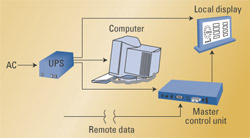
Figure 2. The key school installation consists of a PC, master control unit and remote display of weather parameters. Click here to see an enlarged diagram.
A streaming server provides the real-time weather data to the Internet and simultaneously to the remote computer. The weather stations with cameras have images transmitted to the weather network control center every five minutes.
The entire system is self-contained and operates 24 hours a day, providing real-time, up-to-the-second weather observations. Most of the network’s weather stations are based at local schools that subscribe to an in-classroom curriculum program called WeatherBug Achieve.
The first consideration is where to locate the outdoor weather station instruments. (See Figure 3.) Consider that these systems are not like antennas and should not be mounted multi-stories above ground or on high structures. When possible, they should be located at ground level because that’s the environment that viewers experience. Look for an open area clear of wind obstructions that is far away from ventilation and heat sources. They should be safe from vandalism and far away from large asphalt or concrete parking lots or building walls because these surfaces re-radiate heat.
If the system is located near a school, an optional set of classroom equipment can be installed. This consists of a PC connected via cable to the remote station and its sensors. The PC station also houses indoor barometric pressure, temperature and auxiliary temperature sensors. An optional LED display is continually updated with daily temperature highs, lows and rates of change.
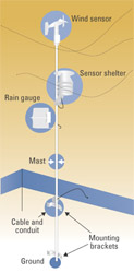
Figure 3. The outdoor sensors should be mounted at ground level if possible, away from heat sources or large heat re-reradiating surfaces. Click here to see an enlarged diagram.
The local perspective
Supported by the network of weather stations and the data provided by the company’s meteorologists, broadcasters can develop compelling weather presentations at the micro-local level. Broadcasters with the Zoom product can create presentations that include real-time weather data combined with time-lapse image loops. Presenters also can combine time-lapse images with associated weather data onto one map background and then zoom into each one for detailed, real-time weather information. The software relies on a simple-to-learn layout, complete with pre-defined templates, and it is highly configurable for local applications.
As television stations better understand the benefits from an emphasized local presence, new tools such as customized local weather will become even more important. This approach to gathering local weather data for on-air presentation is simple, versatile and applicable around the world.
Weather is a common human interest. When stations add this level of localism to their weathercasts, they can begin to build an even stronger attachment with viewers.
Ileana Endom is a product manager and James Aman is a meteorologist with WeatherBug Media Services.
