NBCU taps NASA HD for Gulf Oil Spill

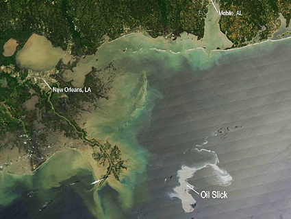
Updated satellite HD video and still images of the spill are being provided by NASA and featured on NBC Universal's Bay Area Web site.
"The devil is in the detail" might be a sadly apt phrase for the fact that NASA, meteorologists, local news operations and ultimately the public are able to see the looming tragedy still unfolding in the Gulf. That also holds true in a market on a different coast on a different ocean, such as San Francisco (DMA 6).
According to NASA via NBC Bay Area online, early this week the majority of the heavier crude oil from the BP oil rig disaster 50 miles off the coast of Louisiana still remained offshore. Meanwhile, however, lighter crude oil (quite noticeable in the HD imagery as the lighter colored areas in the HD image capture) continued to close in on the coastlines of Louisiana, Mississippi and Alabama.
Updated satellite HD video and still images of the spill are being provided by NASA and featured on NBC Universal's Bay Area Web site.
The detailed HD imagery not only pinpoints the path of crude oil as it threatens marshland, wildlife habitats, beaches and commercial fishing areas — but it also would indicate any major encroachments if and when the oil makes landfall. As of late Tuesday (May 4), petroleum engineers were still trying to inject dispersants at the oil's source nearly a mile beneath the surface of the Gulf. Scientists were also still devising untried methods of stopping — or slowing — the dissemination of the crude.
The professional video industry's #1 source for news, trends and product and tech information. Sign up below.
