Using ASTER for More Accurate Coverage Studies
Doug Lung Predicting digital TV coverage in urban areas is difficult. Buildings and groupings of high-rise buildings create urban “mountains” that don’t exist in the U.S. Geological Survey (U.S.G.S.) terrain databases typically used for coverage studies. Fewer buildings have outdoor antennas so building penetration loss is an issue.
To make things even more complicated, an area that is shadowed by a high-rise building may actually get a usable signal via back-scatter from another high-rise building.
More complex computer modeling takes some of this into account, but most readers won’t have the resources, financial or computational, to build accurate coverage models of a city using expensive building databases and ray-tracing software. It is possible, however, to identify potential problem areas using digital elevation models that, to some extent, include buildings.

TERRAIN DATABASES
Standard U.S.G.S. digital elevation models used in the FCC’s TVStudy and most Longley-Rice programs do not include any man-made structures, no matter how large.
In previous articles I showed how use of the Shuttle Radar Topography Mapping (SRTM) mission elevation data could be used to show the impact of buildings. It is not a precise model because not all building roofs work as good radar reflectors, but overall it provides a better picture of coverage than the U.S.G.S. terrain data.
Coverage maps I created during the DTV transition using SRTM and posted on-line using a Google Maps overlay turned out to be a surprisingly accurate representation of coverage. Most of the callers with reception problems were in an area identified as shadowed. Sometimes those areas were only a block or two in size. The SRTM data was collected in February 2000 so any changes since that date are not reflected.
The original twin towers of the World Trade Center are still there and the many newer buildings are not. I’d been looking at the “ASTER” terrain data set.
Get the TV Tech Newsletter
The professional video industry's #1 source for news, trends and product and tech information. Sign up below.
The Advanced Spaceborne Thermal Emission and Reflection Radiometer (ASTER) is one of the sensor systems on-board the Terra satellite. It was developed jointly by NASA in the U.S. and Japan’s Ministry of Economy, Trade and Industry. I used the ASTER Global Digital Elevation Model Version 2. Readers are advised “that the products still may contain anomalies and artifacts that will reduce its usability for certain applications, because they can introduce large elevation errors on local scales. The data are provided ‘as is’ and neither NASA nor METI/ERSDAC will be responsible for any damages resulting from use of the data.”
The files I found for ASTER were created in 2011. The data is only available in one-second resolution, which can result in very large images and matrices when used with a propagation program like SPLAT!.
ASTER files are through the online Data Pool at the NASA Land Processes Distributed Active Archive Center (LP DAAC), U.S.G.S./Earth Resources Observation and Science (EROS) Center, Sioux Falls, S.D., and can be downloaded from www.earthexplorer.usgs.gov.
OBTAINING AND USING ASTER
The ASTER data is provided as a GeoTiff file in tiles one degree on a side. I recommend using the U.S.G.S. bulk downloader program. With it you can download up to 100 files at one time. You will need to register before downloading the data, but there is no charge for the ASTER files.
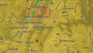
Fig. 1: Coverage using 3-second U.S.G.S. DEM data
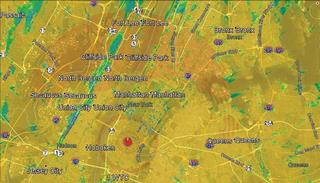
Fig. 2: Coverage using 1-second SRTM data
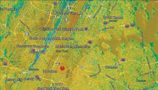
Fig. 3: Coverage using 1-second ASTER GDEM data
It is unlikely your software will be able to use the GeoTiff files directly. Conversion isn’t difficult using GDAL. I’ve posted some of the scripts on my SPLAT! Resources page at www.xmtr.com/splat/ to make the process easier.
Remember when using SRTM or ASTER data, the buildings and tree canopy are now part of the terrain. I typically use a 4-meter receive antenna height above ground (AGL) as a compromise. For the transmit antenna, you will need to subtract the difference between the ASTER or SRTM height and the U.S.G.S. height from the AGL of the transmit antenna to end up with the correct height above mean sea level (AMSL).
When using SPLAT!, be sure to verify the antenna height ASML is correct in the SPLAT! report file. Adjust the antenna height AGL to compensate for the elevated terrain and rerun the study if needed.
Running a coverage study using 1-second terrain data will take a long time, even with a fast quad-core processor and lots of memory. I’ve created some maps of Manhattan that show the differences in the elevation models.
These coverage maps are based on a non-directional panel antenna on the top of the Empire State Building at 452m AMSL. I used a typical elevation pattern for this type of antenna to provide a more even signal distribution over the area. The maps were created using the field strength plot option in SPLAT with standard Longley-Rice environment parameters.
Fig. 1 shows the coverage as plotted using the 3-second USGS terrain data. While the mountains in New Jersey are clearly visible, the signal level over Manhattan is uniform except where there are nulls in the transmit antenna elevation pattern.
Fig. 2 uses the same parameters except the SRTM 1-second terrain data was used. The impact of the buildings is clearly visible. Notice the shadows from the “midtown mountain” of buildings north of Empire and the impact of the original World Trade Center towers to the south.
Fig. 3 is the same as Fig. 2 except for the use of ASTER 1-second terrain data from 2011. You can see the shadows have changed significantly. The long shadow from the World Trade Center is gone and there are many more small shadows from other buildings in Manhattan.
The shadows seem a bit too deep in these plots. In a future column I’ll compare results using Sid Shumate’s ITWOM model in SPLAT!.
Comments and questions are welcome. Email me atdlung@transmitter.com.
Doug Lung is one of America's foremost authorities on broadcast RF technology. As vice president of Broadcast Technology for NBCUniversal Local, H. Douglas Lung leads NBC and Telemundo-owned stations’ RF and transmission affairs, including microwave, radars, satellite uplinks, and FCC technical filings. Beginning his career in 1976 at KSCI in Los Angeles, Lung has nearly 50 years of experience in broadcast television engineering. Beginning in 1985, he led the engineering department for what was to become the Telemundo network and station group, assisting in the design, construction and installation of the company’s broadcast and cable facilities. Other projects include work on the launch of Hawaii’s first UHF TV station, the rollout and testing of the ATSC mobile-handheld standard, and software development related to the incentive auction TV spectrum repack.
A longtime columnist for TV Technology, Doug is also a regular contributor to IEEE Broadcast Technology. He is the recipient of the 2023 NAB Television Engineering Award. He also received a Tech Leadership Award from TV Tech publisher Future plc in 2021 and is a member of the IEEE Broadcast Technology Society and the Society of Broadcast Engineers.
