TVB Tech Alert: iPhone App Identifies and Tracks Aircraft

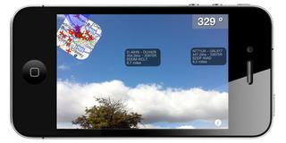
SOUTHSEA, HAMPSHIRE, U.K.: A recently released iPhone app is causing concern in security circles, reports indicate. The Plane Finder AR app from U.K.-based Pinkfroot allows users to aim iPhones skyward and see the location, altitude and speed of nearby aircraft.
“Plane Finder provides real-time information on planes and flights in the U.K., Ireland, Europe, Australia, Southern Scandinavia and increasingly in the U.S. It’s easy to use and is fully integrated into Google Maps,” the app page states. “Plane Finder also includes flight route information and the airline details. It’s also easy to switch between map views, satellite view and information; it even pulls in photos of the planes.... This technology is actually faster than radar and is used in some places for air traffic control and navigation.”
Coverage areas continue to grow as airlines adopt automatic dependent surveillance-broadcast technology. ADS-B transmits unencrypted information on the location, altitude and speed of an aircraft to air-traffic controllers and other aircraft. U.S. coverage includes Washington, D.C., Baltimore, Phoenix, Rhode Island, Denver, Upstate New York and New York City as well as East Ontario, Calif.
Security officials consider the $4.99 app a threat, according to the U.K.’s Daily Mail. The publication said it was labeled an “aid to terrorists” who might use it to manipulate or destroy commercial aircraft. A Pinkfroot executive noted that Plane Finder uses unencrypted data available to anyone ADS-B technology. The DM reports that Plane Finder’s been downloaded by 2,000 people since it launched last month.
Get the TV Tech Newsletter
The professional video industry's #1 source for news, trends and product and tech information. Sign up below.
